Showing 1121 items matching back creek
-
 Surrey Hills Historical Society Collection
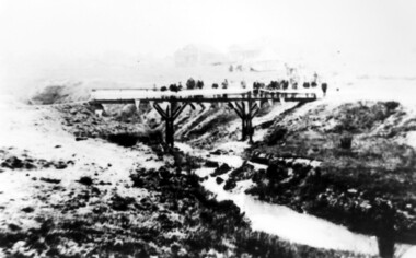
Photograph, Opening of the footbridge across Back Creek, 1936
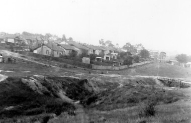
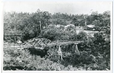
... Opening of the footbridge across Back Creek, 1936...back creek... Back Creek by Sir Winston Dugan, Governor of Victoria, in 1936... of the footbridge across Back Creek in the area later known as South Surrey... of the footbridge across Back Creek in the area later known as South Surrey ...This photo was taken at the opening of the footbridge over Back Creek by Sir Winston Dugan, Governor of Victoria, in 1936. He is cutting bunting draped along the bridge rails. South Surrey Park was developed on land which had been the property of the Kleinert family. Their land extended from Union Road to Essex Road. They ran horses, ducks and fowls and Emily Kleinert grew flowers. Alan Holt research: Lot 6 was sold to Martin Klienert by Karl Richter in 1860 together with a portion of another adjacent lot. From 1860-1885 Martin worked it as a market garden leasing some land for grazing when it was not required for gardening. He died in 1898. In a formal document, William declared he was the son of Martin "who purchased land in 1860, died in 1898 and the land has been continually occupied by father and family since. It has been cultivated as a market garden; when not being used for gardening it was let for cultivation and grazing." William died in 1939 and the property passed to his sons Martin and Ernest. The family sold the land to the Camberwell Council in the 1950s.This photo is significant as it documents the change from rural to urban land use in the area.Black and white photo taken at the opening of the footbridge across Back Creek in the area later known as South Surrey Park. Back Creek runs diagonally through the photo with a wooden footbridge prominent. Dignitaries are gathered on the bridge. A tent and houses can just be distinguished in the background.parks and reserves, creeks, south surrey park, civic occasion, official events, back creek, verdun street, footbridges, governor of victoria, sir winston duggan, surrey hills, kleinert family, (mr) karl richter, (mr) martin kleinert, topography -
 Surrey Hills Historical Society Collection
Photograph, Opening of the footbridge across Back Creek, 1936
... Opening of the footbridge across Back Creek, 1936...back creek... Back Creek by Sir Winston Dugan, Governor of Victoria, in 1936... of the footbridge across Back Creek in the area later known as South Surrey... of the footbridge across Back Creek in the area later known as South Surrey ...This photo was taken at the opening of the footbridge over Back Creek by Sir Winston Dugan, Governor of Victoria, in 1936. He is cutting bunting draped along the bridge rails. South Surrey Park was developed on land which had been the property of the Kleinert family. Their land extended from Union Road to Essex Road. They ran horses, ducks and fowls and Emily Kleinert grew flowers. Alan Holt research: Lot 6 was sold to Martin Klienert by Karl Richter in 1860 together with a portion of another adjacent lot. From 1860-1885 Martin worked it as a market garden leasing some land for grazing when it was not required for gardening. He died in 1898. In a formal document, William declared he was the son of Martin "who purchased land in 1860, died in 1898 and the land has been continually occupied by father and family since. It has been cultivated as a market garden; when not being used for gardening it was let for cultivation and grazing." William died in 1939 and the property passed to his sons Martin and Ernest. The family sold the land to the Camberwell Council in the 1950s.This photo is significant as it documents the change from rural to urban land use in the area.Black and white photo taken at the opening of the footbridge across Back Creek in the area later known as South Surrey Park. Back Creek runs diagonally through the photo with a wooden footbridge prominent. Dignitaries are gathered on the bridge. A tent and houses can just be distinguished in the background.parks and reserves, creeks, south surrey park, civic occasion, official events, back creek, verdun street, footbridges, governor of victoria, sir winston duggan, surrey hills, kleinert family, (mr) karl richter, (mr) martin kleinert, topography -
Surrey Hills Historical Society Collection
Archive
... Back Creek...Back Creek is one of the tributaries of Gardiners Creek...A vertical file containing information about Back Creek...Back Creek is one of the tributaries of Gardiners Creek ...Back Creek is one of the tributaries of Gardiners Creek. It rises as a spring on the slopes of the hill at the corner of Canterbury Road and Elgar Road in Surrey Hills, the location of a Melbourne Water tower and reservoir. It has been channelled underground from this point in pipes as far as Union Road. South Surrey Park runs along both sides of Back Creek from where the creek crosses Union Rd near Rose Avenue to where it crosses Riversdale Road just west of Through Road. A vertical file containing information about Back Creek in Surrey Hills: 1. 4 colour photos taken in 1983 (1 page). 2. ‘Pipe dreams run their course’, (Boroondara Review ?) 17.4.2013 (1 page). 3. ‘Plan rainchecked for creek impact’, Boroondara Review, 13.3.2013 (2 pages). back creek -
 Eltham District Historical Society Inc
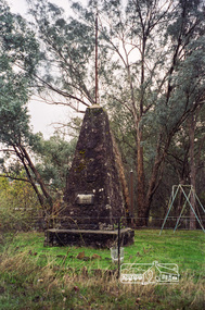
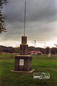
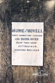
Photograph, Hume and Hovell Monument, Back Creek Road, old Back Creek school site, Back Creek, c.1998, 1998c
... Hume and Hovell Monument, Back Creek Road, old Back Creek...Back Creek...), Myrtleford, Whorouly, Everton, Murmungee, Stanley, Back Creek... melbourne Photograph Hume and Hovell Monument, Back Creek Road, old ...Stage 3 tour of Hume and Hovell monuments organised by Russell Yeoman. At the centenary of Hume and Hovell exploration in 1924 a committee was formed to co-ordinate and organise local celebrations along the route from Albury to Corio Bay. An itinerary was created for the unveiling ceremonies giving the hour and date for each place concerned from 15 to 21 November 1924. Thirty-three monuments or cairns were erected at Violet Town, Euroa, Avenel, Seymour, Broadford, Kilmore, Mount Bland, Bulla, Moyhu, Hansonville, Benalla, Samaria, Swanpool, Yarck, Yea, The Horn (Buffalo), Myrtleford, Whorouly, Everton, Murmungee, Stanley, Back Creek, Allan's Flat, Staghorn Flat, Ebden, Bethanga, Hume Reservoir, Strath Creek, Deer Park, Werribee, Lara, Bulla, Everton.Roll of 35mm colour negative film, 7 stripsKodak Gold 200-6activities, back creek, hume and hovell, monument -
 Eltham District Historical Society Inc
Photograph, Hume and Hovell Monument, Back Creek Road, old Back Creek school site, Back Creek, c.1998, 1998c
... Hume and Hovell Monument, Back Creek Road, old Back Creek...back creek...), Myrtleford, Whorouly, Everton, Murmungee, Stanley, Back Creek... melbourne Photograph Hume and Hovell Monument, Back Creek Road, old ...Stage 3 tour of Hume and Hovell monuments organised by Russell Yeoman. At the centenary of Hume and Hovell exploration in 1924 a committee was formed to co-ordinate and organise local celebrations along the route from Albury to Corio Bay. An itinerary was created for the unveiling ceremonies giving the hour and date for each place concerned from 15 to 21 November 1924. Thirty-three monuments or cairns were erected at Violet Town, Euroa, Avenel, Seymour, Broadford, Kilmore, Mount Bland, Bulla, Moyhu, Hansonville, Benalla, Samaria, Swanpool, Yarck, Yea, The Horn (Buffalo), Myrtleford, Whorouly, Everton, Murmungee, Stanley, Back Creek, Allan's Flat, Staghorn Flat, Ebden, Bethanga, Hume Reservoir, Strath Creek, Deer Park, Werribee, Lara, Bulla, Everton.Roll of 35mm colour negative film, 7 stripsKodak Gold 200-6activities, back creek, hume and hovell, monument -
 Ballarat Heritage Services
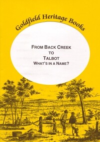
Book, Marie Kau, From Back Creek to Talbot
... From Back Creek to Talbot...Back Creek...From Back Creek to Talbot was published by BHS Publishing... Office goldfields Book From Back Creek to Talbot Yellow soft ...From Back Creek to Talbot was published by BHS Publishing and written by Marie Kau. Yellow soft covered booklet on Talbot, Victoria.talbot, back creek -
 Surrey Hills Historical Society Collection
Photograph, Back Creek (later South Surrey Park), c 1936, 1936
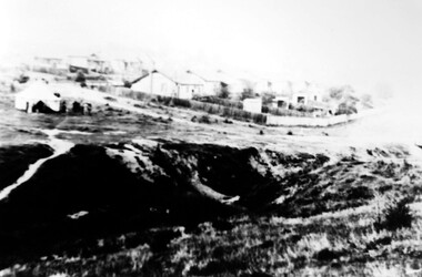
... Back Creek (later South Surrey Park), c 1936...back creek... as South Surrey Park. Back Creek is in the foreground...Photograph Photograph Back Creek (later South Surrey Park ...This photo was taken at the opening of the footbridge by Sir Winston Dugan in 1936.South Surrey Park was developed on land which had been the property of the Kleinert family. Their land extended from Union Road to Essex Road. They ran horses, ducks and fowls and Emily Kleinert grew flowers. Alan Holt research: Lot 6 was sold to Martin Klienert by Karl Richter in 1860 together with a portion of another adjacent lot. From 1860-1885 Martin worked it as a market garden leasing some land for grazing when it was not required for gardening. He died in 1898. In a formal document, William declared he was the son of Martin "who purchased land in 1860, died in 1898 and the land has been continually occupied by father and family since. It has been cultivated as a market garden; when not being used for gardening it was let for cultivation and grazing." William died in 1939 and the property passed to his sons Martin and Ernest. The family sold the land to the Camberwell Council in the 1950s.This photo is significant as it shows the transition from rural to urban land use in Surrey Hills.Black and white photo taken in the area later known as South Surrey Park. Back Creek is in the foreground. There is a tent on the LHS and approximately 7 houses which front Verdun Street. Some of their backyards face onto the open space along the creek bed.parks and reserves, creeks, south surrey park, civic occasion, official events, back creek, verdun street, 1936, kleinert family, sir winston dugan, topography -
 Surrey Hills Historical Society Collection
Photograph, Back Creek (later South Surrey Park), c 1936, 1936
... Back Creek (later South Surrey Park), c 1936...back creek... as South Surrey Park. Back Creek is in the foreground...Photograph Photograph Back Creek (later South Surrey Park ...This photo was taken at the opening of the footbridge by Sir Winston Dugan in 1936.South Surrey Park was developed on land which had been the property of the Kleinert family. Their land extended from Union Road to Essex Road. They ran horses, ducks and fowls and Emily Kleinert grew flowers. Alan Holt research: Lot 6 was sold to Martin Klienert by Karl Richter in 1860 together with a portion of another adjacent lot. From 1860-1885 Martin worked it as a market garden leasing some land for grazing when it was not required for gardening. He died in 1898. In a formal document, William declared he was the son of Martin "who purchased land in 1860, died in 1898 and the land has been continually occupied by father and family since. It has been cultivated as a market garden; when not being used for gardening it was let for cultivation and grazing." William died in 1939 and the property passed to his sons Martin and Ernest. The family sold the land to the Camberwell Council in the 1950s.This photo is significant as it shows the transition from rural to urban land use in Surrey Hills.Black and white photo taken in the area later known as South Surrey Park. Back Creek is in the foreground. There is a tent on the LHS and approximately 7 houses which front Verdun Street. Some of their backyards face onto the open space along the creek bed.parks and reserves, creeks, south surrey park, civic occasion, official events, back creek, verdun street, 1936, kleinert family, sir winston dugan, topography -
 Surrey Hills Historical Society Collection
Photograph, Footbridge across Back Creek, 1980
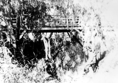
... Footbridge across Back Creek, 1980...back creek... in 1936. parks and reserves creeks south surrey park back creek ...South Surrey Park was developed on land which had been the property of the Kleinert family. Their land extended from Union Road to Essex Road. They ran horses, ducks and fowls and Emily Kleinert grew flowers. Alan Holt research: Lot 6 was sold to Martin Klienert by Karl Richter in 1860 together with a portion of another adjacent lot. From 1860-1885 Martin worked it as a market garden leasing some land for grazing when it was not required for gardening. He died in 1898. In a formal document, William declared he was the son of Martin "who purchased land in 1860, died in 1898 and the land has been continually occupied by father and family since. It has been cultivated as a market garden; when not being used for gardening it was let for cultivation and grazing." William died in 1939 and the property passed to his sons Martin and Ernest. The family sold the land to the Camberwell Council in the 1950s. The original footbridge was opened by Sir Winston Dugan in 1936.Black and white photo of a wooden footbridge with large trees and shrubs obscuring its surrounds.parks and reserves, creeks, south surrey park, back creek, verdun street, footbridges -
Federation University Historical Collection
Booklet, E.J. Dunn, The Back Creek Silver-Lead Mine, near Buchan, Eastern Gippsland, 1905
... The Back Creek Silver-Lead Mine, near Buchan, Eastern... The Back Creek Silver-Lead Mine, near Buchan, Eastern Gippsland ...Sixteen page booklet.gippsland, buchan, dickson's caves, basin creek caves, murrinfal river, wilon's caves, buchan limestone, mt tara goldfield, taedato creek gold workings, dominion copper mine, queen roeed, micawbet mne, surprise mine, good hope mine -
 Ballarat Heritage Services
Book, The Governor's Visit to Back Creek/Talbot
... The Governor's Visit to Back Creek/Talbot... Office goldfields Book The Governor's Visit to Back Creek/Talbot ...One of a series of Goldfield Heritage Books, The Governor's Visit was published by BHS Publishing and written by Marie Kau. -
 Ballarat Heritage Services
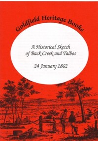
Book, A Historical Sketch of Back Creek and Talbot 24 January 1862
... A Historical Sketch of Back Creek and Talbot 24 January... Office goldfields Book A Historical Sketch of Back Creek ...One of a series of Goldfield Heritage Books, A Historical Sketch was published by BHS Publishing and written by Marie Kau. talbot, marie kau -
 Surrey Hills Historical Society Collection
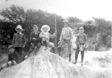
Photograph, Boys who later joined the 1st Surrey Hills scout troop, 1909
... back creek... in the eroded creek bed, called 'The Alps', of Back Creek opposite... of scrub in the eroded creek bed, called 'The Alps', of Back Creek ...1st Surrey Hills was the 3rd troop formed in Victoria. Harrison Buchanan was not old enough to join and for a time was the 'troop mascot' as the cubs had not been formed at this time. He later became the troop's 2nd Scoutmaster. Doug Jeffries lived at 12 Vincent Street. Alex Lucas was the son of the draper in Canterbury Road. Our documentation variously gives the date as 1901 or 1909.Six boys are pictured against a backdrop of scrub in the eroded creek bed, called 'The Alps', of Back Creek opposite Wattle Park. Three of them are identified as: Harrison Buchanan (with the stave), Doug Jeffries on the LHS and Alex Lucas next to him.Black and white photo measuring L 24.5 cm x H 17.4 cmback creek, 1st surrey hills scout troop, scouts, harrison buchanan, alex lucas, doug jeffries, childhood and youth, topography -
 Eltham District Historical Society Inc
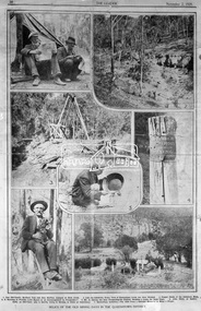
Negative - Photograph, The Leader, Relics of the Old Mining days in the Queenstown District, 2 Nov 1929
... Back Creek... Tom and Alex McPhee, Camped on Back Creek. 2. Like... on Back Creek. 2. Like the Caledonia, Every Yard of Queenstown ...Queenstown (St. Andrews) District. Originally published in The Leader, Nov. 2nd, 1929, p30, with the title "Relics of the Old Mining days in the Queenstown District," a series of seven numbered photographs with captions : 1. Two Old-Timers, Brothers Tom and Alex McPhee, Camped on Back Creek. 2. Like the Caledonia, Every Yard of Queenstown Creek has been Washed. 3. Poppet Heads of the Caledonia Mine. 4. A Warning to Possible Land Buyers or Encouragement to Prospectors? 5. Mr. A. Harvey has been Prospecting the District, Washing a Loam, for Some Years. 6. John Olsen, of Smith's Gully, an Old-Timer, who is Shortly Going to Norway to Claim an Inheritance. 7. Queenstown Cemetery. - The Hills Form a Splendid Memorial to Many a Digger.This photo forms part of a collection of photographs gathered by the Shire of Eltham for their centenary project book,"Pioneers and Painters: 100 years of the Shire of Eltham" by Alan Marshall (1971). The collection of over 500 images is held in partnership between Eltham District Historical Society and Yarra Plenty Regional Library (Eltham Library) and is now formally known as the 'The Shire of Eltham Pioneers Photograph Collection.' It is significant in being the first community sourced collection representing the places and people of the Shire's first one hundred years.Digital image 4 x 5 inch B&W Negsepp, shire of eltham pioneers photograph collection, queenstown, gold mining, a. harvey, alex mcphee, back creek, caledonia mine, john olsen, poppet heads, queenstown cemetery, queenstown creek, smiths gully, st. andrews, tom mcphee -
 Eltham District Historical Society Inc
Photograph, Hume and Hovell Monument, Memorial Park Sports Ground, Whorouly, c.1998, 1998c
... back creek...), Myrtleford, Whorouly, Everton, Murmungee, Stanley, Back Creek..., Stanley, Back Creek, Allan's Flat, Staghorn Flat, Ebden, Bethanga ...Stage 3 tour of Hume and Hovell monuments organised by Russell Yeoman. At the centenary of Hume and Hovell exploration in 1924 a committee was formed to co-ordinate and organise local celebrations along the route from Albury to Corio Bay. An itinerary was created for the unveiling ceremonies giving the hour and date for each place concerned from 15 to 21 November 1924. Thirty-three monuments or cairns were erected at Violet Town, Euroa, Avenel, Seymour, Broadford, Kilmore, Mount Bland, Bulla, Moyhu, Hansonville, Benalla, Samaria, Swanpool, Yarck, Yea, The Horn (Buffalo), Myrtleford, Whorouly, Everton, Murmungee, Stanley, Back Creek, Allan's Flat, Staghorn Flat, Ebden, Bethanga, Hume Reservoir, Strath Creek, Deer Park, Werribee, Lara, Bulla, Everton.Roll of 35mm colour negative film, 7 stripsKodak Gold 200-6activities, back creek, hume and hovell, monument -
 Bendigo Historical Society Inc.
Article - Various Indexes
... Back Creek Cemetery...; TC Watts 1920s photos of house sales; Back Creek Bendigo... photos of house sales; Back Creek Bendigo Cemetery - First Year ...Collection of indexes - Business advertisements St Patrick's Annual Sports 1934; White Hills Residents 1907-1908; Business Advertisements from Directories 1865, 1872, 1875, 1904, 1907, 1910; Bendigo Chamber of Commerce 1903, 1913, 1920, 1946; TC Watts 1920s photos of house sales; Back Creek Bendigo Cemetery - First Year Burials; Wills administered by Sandhurst Trustees; 1842-1866 277 Mining Deaths from Inquet records for Sandhurst; The Bendigonian Annual 1910. Compiled by Carol Holsworth. Collection is in plastic pockets, contained in a white A4 three ring binder. Fourteen plastic pockets in total. st patrick's annual sports, bendigo businesses, white hills residents, bendigo chamber of commerce, house sales, t.c.watts, back creek cemetery, sandhurst trustees, mining deaths, the bendigonian -
 Surrey Hills Historical Society Collection
Photograph - Mrs Long's house, Delta Street area, Surrey Hills
... back creek..., on the north side of Back Creek. Once roads were made and streets... that later became Delta Street, on the north side of Back Creek. Once ...The property is in the area that later became Delta Street, on the north side of Back Creek. Once roads were made and streets numbered, this became 1 Delta Road, Surrey Hills. Part of the undeveloped land would become part of South Surrey Park. According to Alan Holt's property register the house was built in c1920 and was demolished after having been neglected in 1991. He records it having had various names: 'Westward Ho', 'Pembroke' and 'The Oaks'. The first owner from 1920 was Eric Rowland Handyside Long who married Agnes May Hay Murray in March 1920. They had one son James Murray Long, born in September 1921. They divorced in 1937 and thereafter the property is listed in the name of Mrs Mary Hay Long, James M Long or Miss Mary Hay Long. According to Alan Holt, the house featured in the television series 'Carson's Law' in c1984.This is one of relatively few photos which record the transformation of rural land into the suburb that became Surrey Hills.A simple dark-stained timber house with a veranda and tiled roof. It is simply fenced with posts and wire mess. There are other houses in the background but part of the area remains as open space.delta road, back creek, south surrey park, wetward ho, pembroke, the oaks, hose names, miss agnes may hay murray, mrs agnes may hay long, mrs mary hay long, miss mary hay long, james murray long, carson's law -
 Surrey Hills Historical Society Collection
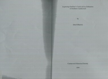
Book, Exploring Gardiner's Creek and its tributaries in southern Camberwell, 1994
... back creek... koonung creek back creek glass's creek w creek west creek ...This book describes geographical landmarks and especially waterways that of the City of Camberwell (now City of Boroondara).This book describes geographical landmarks and especially waterways that of the City of Camberwell (now City of Boroondara).gardiner's creek, (mr) john gardiner, koonung creek, back creek, glass's creek, w creek, west creek, ashburton creek, delaney's creek, walking trails, rivers -
 Surrey Hills Historical Society Collection
Book, Alan Judge Holt (deceased), Pre-Suburban Surrey Hills 1839-1883, 1989
... back creek... massora aborigines damper creek back creek west creek kooyongkoot ...Author: Alan Judge Holt amassed a significant collection of historical material related to the Surrey Hills area. Born in Moonee Ponds in 1912 to Edmund Holt and Ellen Ruby Sutton, he married Edna Jean Pallot in 1937. They lived at 62 Broughton Road, Surrey hills, had 3 sons and were strongly associated with the Surrey Hills Methodist Church. Alan was Secretary of the Victorian Lands Department and in his spare time recorded the occupancy of every property in Surrey Hills and Mont Albert at the beginning of each decade from 1890 to 1980. His collection of files and individual cards covers people, places, churches, clubs, businesses and other organisations in the area. Alan used this information to give talks and tours of the area and gifted his material to the local history collection through Jocelyn Hall.Unpublished manuscript / notes written by Alan Holt about settlers in and around Surrey Hills bound in-house. It is supported by maps showing landowners over various years from about 1840-1885(mr) henry jamieson, (mr) ken hall, (ms) edna holt, (mr) frank bamford, (mr) harrison buchanan, scouts, grange hill, wattle park, round hill, bona vista, mount albert, barton street, (mr) john raeburn, (mr) edmund holt, (mr) james dunn, butter merchant, mont albert road, elgar road, view hill, new street, surry mont, delany's hill, reservoir hill, riversdale road, middlesex road, surrey hills, (mr) aldo massora, aborigines, damper creek, back creek, west creek, kooyongkoot creek, (mr) john gardiner, (mr) chas mullins, (mr) henry elgar, (mr) robert campbell, (mr) alexander dyce, (mr) robert brooks, t budds payne, (mr) hugh glass, (mr) patrick trainer, w virtue, (mr) t fulton, (mr) john crimp, (mr) w dempsey, (mr) w e stanbridge, (mr) james atkinson, j porter, j collings, w edde, (mr) orlando fenwick, (dr)(mr) l l smith, (mr) j h knipe, (mr) george cockcroft, (sr) (mr) john martin kleinert, w morton, d delaney, a moeller, (mr) william smith, (mr) e.p.s.sturt, (mr) thomas blood, (mr) patrick mornane, (mr) henry de carle, w craig, j hill, w oliver, j keogh, a laing, vineyards, toll gates, (mr) david staig, (mr) phillip kleeper, (mr) goyder usher, (mr) james lawler, (mr) w.e. stanbridge, (mr) gideon rutherford, c a f mater, j gadsby, w h wrixon, e h lamont, i ainger, (mr) james henty, (mr) henry henty, w freemantle, w palmer, beckett park, maranoa gardens -
 Surrey Hills Historical Society Collection
Book, Exploring Gardiner's Creek and its tributaries in southern Camberwell, 1994
... back creek... gardiner koonung creek back creek glass's creek w creek west creek ...This book describes geographical landmarks, in particular the waterways, that make up the City of Camberwell (now City of Boroondara).This book describes geographical landmarks, in particular the waterways, that make up the City of Camberwell (now City of Boroondara).gardiner's creek, (mr) john gardiner, koonung creek, back creek, glass's creek, w creek, west creek, ashburton creek, delaney's creek, walking trails, rivers, creeks, glass creek -
Federation University Historical Collection
Document, Zelda Martin, Central Victorian Goldmining towns - Boom Towns or Ghost Towns?, c1996
... back creek... (Back Creek) Brief History Taradale: Post office Directory 1869... back creek Mountain Creek Police court Carisbrook dunolly ...Zelda Martin was a PhD candidate at the University of Melbourne.[.1] 4th item in light blue display book titled Research Approach/Overview of Chapters/Confirmation of Canditure/Chapters1,2,3&4 of proposed thesis. *Twenty-seven page article on Victorian goldfields towns titled: Central Victorian Goldmining Towns - Boom Towns or Ghost Towns. The article was written during the author's PhD study. It outlines the context methodology, and resources and the chapters of the proposed thesis: (1) Central Victorian Goldmining Towns - The Context (2) Contemporary Views of the Factors Necessary for Town Growth (3) Outward Manifestations of Town Growth (4) The Trappings of Government (5-9) The Main Towns and Their Hinterland. [.2] 5th item in Light Blue display book as above item. *Chapter 1 of proposed thesis titled 'Pick, Shovel and Tin Dish Mining.' Covers in Section A: Central Victoria - Pre 1851: Aborigines in Central Victoria, Squatters, and Government. Section B: The years 1851-1854: The Early Gold Rushes, Government Reaction, Township Surveys, Legislation, Town Development, Local Government and Early Settlement. [.3] 6th item in Light Blue display book as above item. *2A of proposed thesis titled 'Contemporary Views of the Factors Necessary for Town Growth'. Similar information to Chapter 1 plus extra re towns and maps. Sections: Introduction, Context of Place - Geographical Towns Listed, The Context of Time - Pre1851 Aborigines, Governance of Port Phillip, The Squatters, The Villages of Central Victorian Highlands, Conclusion, Condensed Version of Chapter2B. [.4] 7th item in Light Blue display book as above item. *Chapter2B of proposed thesis. Sections: Area of Research, Schools, Banks, Newspapers, Progress Association, Town Development - Sandhurst (Bendigo), Ballarat, Castlemaine,, Maryborough, Ararat and Stawell. [.5] 8th item in Light Blue display book as above item. *Chapter 3 of proposed thesis titled 'Outward Manifestations of Town Growth'. Sections: Introduction, Contemporary Writing, Educationalists, The Bankers, The Townsfolk, Current Theory, General Theories of Urban Development, and Conclusion. [.6] 9th item in Light Blue display book as above item. *Chapter 4 of proposed thesis titled 'Trappings of Government' Sections: Introduction, Early Government Attitudes to Mining and Town Development, Law and Order, Township Surveys, Legislation, Local Government, Transport and Communication, The People and Lobbyists. [.7] 10th item in Light Blue display book as above item. *'The Rise and Fall of Central Victorian Goldmining Towns'. Includes a map showing main Goldfields, a table showing towns and villages at two points in time - 1857 and 1871; a Bibliography of Primary and Secondary Sources. [.8] Resource No1. Black display book titled Local Towns 1 : Alma: *Brief history *Directory *Maps Amphitheatre / Mountain Hut: *Brief History Post Office Directory Ararat: *Brief History *Post Office Directory 1869 - Alphabetical Listing by Occupation *Ararat - Prominent Citizens of 1858 *Langi-Morgala Museum Avoca: *Brief History *Excerpts from 'Avoca The Early Years', Margery and Betty Beavis; pg1 - Beginnings; pg11 - The Midas Touch; pg25 - Local Gold Escorts; pg27 - A Town is Born; pg51- The Administration of Justice; pg53 - The Ways of the Law; pg61 - News of the Day; pg65 - A Time to Play; pg72 - Land Ownership *Post Office Directory (Bailliere's) 1869 *Tourism Map and Information of area *Historic Avoca - A 5.5km Tour *Avoca & the Pyrenees Region - information pamphlet Ballarat: *Early History of Ballarat - Ballarat Historical Society, Publication No.1: origin of the name; Ballaarat - the Beginning; Fabulous Yields from the Ballaarat Goldfield; *Streetscape Lydiard Street. *Hand drawn map showing Leigh River, Old Portland Bay Road, plaque on road to Colac; etc. *Newspaper article re 'The Theatre Royal' ( which stood in the vicinity of the current Owen Williams store) - 'The News'15/04/1998 *Article - 'Ballarat's Mechanics' Institute Lives On' Ballarat Courier, 14/09/1985 *Article - Standing the Test of Time' The News 17/11/1993 re The Mechanics Institute & picture of the Reading Room *'Ballarat a Study of a City, Phyllis Reichl, pub. Nelson, 1968; no.3 place, time and people field studies series *Investigator Vol.33 No.2, 1998 Geelong Historical Society. Article on pg75 describes Ballarat in 1861 *Folded poster - 'Ballarat 100' a history of telegraph communication, pub. Telecom. Beaufort (Fiery Creek): *Brief history *Post Office Directory [.9] Resource No.2 Black Folder Titled Towns cont.No2 Bendigo (Sandhurst): *'Family & Local History at the Bendigo Library - 1851-2001 150 years of gold'. *Bendigo Government Camp in 1853 illustration; key to sketch and names of Government officers stationed there *Excerpts from 'Bendigo and Vicinity' Adolph Haman *The Bendigo Goldfield Registry - pgs 1-7 Introduction *Excerpt: 'Breaking the Grip' *Excerpt: The Most Go-Ahead Place *Excerpts from 'History of Bendigo' - anti license agitation; laying out of town; proposed railway; gold calls and dividends; the Sandhurst Municipality; journalism *Bibliography Blackwood: *Excerpts from 'Aspects of Early Blackwood - The Goldfield, the Landmarks, the Pioneers' Alan J Buckingham and Margaret F Hitchcock, JG Publishing,1980 Buninyong: *A Brief History *Investigator Vol1 No.2 Feb 1966 Geelong Historical Society. Pg3 - Article re gold escort route - Mt Alexander to Adelaide - (see a simple monument on the Western Highway a few miles out of Horsham. Pg 15 - Ballarat Excursion - re the finding of gold. *Three articles published by Buninyong and District Historical Society Inc: (Magpie Exploration; Finding Gold In The Green Hills; Magpie Exploration; Burnt Bridge to Cargarie to Mt Mercer) *Copies of newspaper articles/items *Buninyong Street Directory Carisbrook: *In the Beginning There Was Carisbrook *The History of the Carisbrook Racecourse Carngham / Snake Valley: *Brief History *Directory Castlemaine: *Directory 1865-1866 - Alphabetical and Street *Poster - Castlemaine A Contemporary Guide "The Great Centre" 1866 - A Contemporary Guide to the Fascinating Past *Pamphlet - Castlemaine District Community Hospital *Map - Castlemaine, Maldon & Surrounding Districts *Map and Information - The Dry Diggings Track - a 55kl walk among historic goldfields relics ( Castlemaine Fryerstown Vaughan Mt Franklin Hepburn Daylesford) *Postcard - Former Court House *Directory 1867 - Alphabetical, Trade [.10] Resource No.3 Grey folder Titled Towns 3 Creswick to Maryborough Creswick: *Brief History *Booklet - "Creswick Cemetery Walk" *Booklet - The Buried Rivers of Gold Heritage Trail Creswick *Creswick Historical Museum Information Sheet *Chronological History of Creswick *Alphabetical Directory of the Borough of Creswick *Creswick's Creek Directory 1856 *Historic Creswick Walking Tour *A Brief Account of the Schools of Creswick - Past and Present *100 Years of Railway Travel in Creswick *The Berry Deep Leads *The Spence Home at Jackass Gully in the Creswick State Forest ( William Guthrie Spence - Pioneer) *The New Australian Mine and the 1882 Disaster *Creswick District News, Issue 7, July August 1999 *The Creswick Miners Walk - Information and Map *Maps Chewton: *Brief History *Directory Clunes: *Brief History *Clunes Street Directory Daylesford: *Brief History *Notable Bushfires in Daylesford District Over More Than a Century - "Black Thursday" 1851; 1862; 1899; the Disastrous Hepburn Fire of 1906; 1939; 1944; 1969. *Post Office Directory -Daylesford and Hepburn Dunolly / Inkerman: *Brief History *Directory *Pamphlet - Goldfields Historical Museum *Pamphlet - Historic Dunolly - Victoria's Best Kept Secret *Map of Gold Workings at Dunolly Area - showing where the main gold rushes occurred *Brief History - Inglewood *Directory - Inglewood - Name Occupation, Dwelling Kingower: *Brief History *Directory - Name / Ocupation / Dwelling Linton / Happy Valley / Piggoreet: *Brief History *Directory - Lintons McIvor: *"A History of the Shire and the Township of Heathcote" by J.O. Randell Majorca: *Brief History *Official Post Office Directory 1869 - Name / Occupation/ Address Maldon (Tarrangower): *Brief History Part 1 *Brief History Part 2 *Post Office Directory *List - Alphabetical Order by Names plus Business and Trade (Tarrangower Times Oct/1858) *List - Alphabetical Order by Trade plus Name and Business *Directory - Name / Occupation / Dwelling Maryborough: *Worsley Cottage - built by Arthur Worsley, a contractor in stonework in 1894 [.11] Resource No. 4 Blue Display Book titled Towns 4 Moliagul to Stawell Moliagul: *Brief History *Moligul Legislative Assembly (Voting?) List - Names and Occupations *Moliagul Victorian Post Office Directory 1868 - Name / Ocupation / Address / Comments *"The Welcome Stranger" gold nugget *The Sunday School *The Welcome Stranger Discovery Walk - information and map Moonambel (Mountain Creek) Redbank *Brief History *List of names extracted from advertisments of the Pioneer and Mountain Creek Advertiser 16/02/1861. *Bailliere's Directory 1869 - Alphabetical List of Name / Occupation / Place St Arnaud: *Brief History Sebastapol: *Brief History *Directory 1869 - Alphabetical by Name; plus occupation and address. Browns and Scarsdale: *Brief History *Browns Street Directory - Name and Occupation Smythesdale: *Brief Description *Smythesdale Street Directory -Name and Occupation Stawell (Pleasant Creek) *Brief History *Victorian Official Post Office Directory - Name /Occupation / Dwelling *Chronology - 1841-1920 *Production of gold statistics - 1879 - 1900 *Big Hill *Extracts from "The Golden Years of Stawell". Chapt 1 - Stawell's Coming Out. Capt. 2 - The Gold Rush. Caapt.3 - Cradle of Democracy. Chapt.4 - The Reefs Becomes Stawell. Chapt. 5 - Rushing In. Chapt.6 - The Pioneers. Chapt 7 - The Decade of Optimism. [.12] Resource No. 5: Blue Display Book titled 'Towns Steiglitz to the The Golden Triangle. Steiglitz: Brief History Victorian Post Office Directory 1869 *Map of Steiglitz *List of maps relevant to Steiglitz history *Information 6 tables of data from "Reports of Mining Surveyors Talbot (Back Creek) Brief History Taradale: Post office Directory 1869 - Name/Occupation/Street. Also list in alphabetical order by Occupation Taradale *Chronological Reference to Taradale Mines *Water - The Coliban System of Waterworks *Joseph Brady *The Syphon Tarnagulla (Sandy Creek) *Brief History *Tarnagulla Businessmen Cameos to give depth to advertisments in 'The Tarnagulla Courier' various issues 1864-1871 *Directory - Name/Occupation /Address *List - Name/Business/Trade Wedderburn (Koorong) *Brief History *List - Name/Occupation The Golden Triangle: *The Early Rushes - Wedderburn / Moliagul / Sandy Creek - Tarnagulla / Jones Creek - Waanyarra / Kingower / Dunolly - Goldsborough / Inglweood *Census of 1857 - Population / Occupations *1858-1871 - A Time of Consolidation- Wedderburn / Moliagul / Sandy Creek- Tarnagulla / Arnold *Census 1871 - Population *Information gleaned from the census data - Demographics / Population / Occupations / marital / Birthplace / Religion / Literacy/ Occupation and Housing Cameos *Graphs - Birthplace of settlers /Male-Female Ratio / Married males / Children under 15 as Percentage of Population / Religion *Census 1857 - Statistical data *Maps *Bibliography [.13] Resource No. 6 - Black Display Book Information and Research in Central Victoria including: *Banking - Research from ANZ Bank Archives *Institutions - also includes articles listed from the Ballarat Times Newspaper *Australian mining History Association - A.M.H.A. Bibliography *Australia's Mining History * Bibliography - Land Surveys Victoria - *1853 Administration (Statistics and Other) includes: schools / ministers of religion / police / military / local administration / licences for sale of spirits / distances between various Victorian gold fields. * Victoria Government Gazette (Copy) - N0. 116, 12/12/1854 includes: Gold Felds Commission of Enquiry & No. 85, 15/09/1854 - Addresses presented to the Lieutenant Governor (Sir Charles Hotham) during his tour through the Gold Fields of Victoria,1854. Addresses on behalf of : the people of Bendigo; Members of the Church of England, Bendigo; Members of the Wesleyan Church on the Bendigo Gold Fields; Bendigo Gold District General Hospital; the Bendigo Prospecting Association; Committee of the Bendigo Local Exhibition; Bendigo District Medical Association; Coloured Americans Resident at Bendigo; German Inhabitants of Bendigo; Landowners, Inhabitants, and Miners of Castlemaine; Inhabitants of Forest Creek; Inhabitants of Heathcote and Gold Miners of McIvor; Residents and landholders of the District of Bacchus Marsh; Inhabitants of Kilmore and Vicinity. *Gold Fields Correspondence 1853: letter from Lieutenant Colonel Valiant, (Officer commanding the Troops in Victoria) to the Lieutenant Governor re threatened disturbance at Sandhurst (Bendigo) regarding the Gold License Fee. * Extracts from a book "Victoria" re Gold Fields Commission of Enquiry involving mainly Ballarat and Castlemaine and a chapter titled 'A Tour to the Victorian Gold-Fields' *Lists of central Victorian newspapers - listed by date published 1851to 1874; by first date available to State Library. *A list of cities and towns showing County, population in 1861 &1871, and municipal status. [.14] Resource no.7. Black display book. *Reference: Papers presented to Parliament Victoria - 1859-1860 4 volumes - relevant sections copied. Contains information on Branches of Government. General / Finance / Gold / Gazette / Commission and Warrant / Statistic. *Gold Fields Act. In accordance with the Act the gold fields are divided into six districts - Ballaarat, Castlemaine , Sandhurst, Avoca, Ararat, and Beechworth.. Official staff in each gold district consists of a Resident Warden, Wardens, Wardens' Clerks, Bailiffs, Chinese Protectors, Chinese Interpreters, and Mining Surveyors. *Gold Receiver *Gaols *Police magistrates and Clerks of Petty Sessions, etc. *Field Branch *Immigration and Emigration Overland - Chinese - 1859 *Population on the Goldfields *The Geological Survey - The Government Geologist is assisited by staff from four branches - the office Branch; the Publishing Branch; the Field Branch and the Museum Branch. *Commission to Enquire Into Sludge dated 10/02/1859 (Some sections copied) - Report to the Honorable Chief Commissioner of Public Works, Melbourne re the mode of carrying the sludge from the puddling mills in Sandhurst without interfering with the drainage of the town and the roads in the neighbourhood. [.15] Resource No.8: Camel display book titled Resource No. 8. Aborigines *Lists of book titles - +"Readings in Victorian prehistory" +"The Aborigines of Port Phillip" +Aboriginal languages and clans" +"A History of the Port Phillip District" +"Langi Ghiran 1: Aboriginal Rock...." +"Koorie History: sources for aboriginal studies in the State Library of Victoria", ed. Tom Griffiths, Melb. Friends of the State Library, 1989 +"The Public Lands of Australia Felix"; settlement and land appraisal in Victoria1834-91 with special reference to the Western Plains", J.M.Powell, Melb. Oxford University Press 1970 +*Bibliography of the Victorian Aborigines' from the earliest manuscripts to 31st December 1970, Massoa, Aldo, Melb. Hawthorn Press, 1971 +"Aborigines in Colonial Victoria, 1836-1886", M.F. Christie, Sydney University Press, 1979 +"Urban and Industrial Australia: readings in Human Geography" ed J.M. Powell, Melb. Sorrett Pub. 1974 *Extracts: -Processes of Pioneer Settlement - The Squatting Occupation of Victoria, 1834-60. J.M. Powell -Areal Variations in the Class Structure of the Central-Place Hierarchy. P. Scott - Volume1 and Volume 2: Notes Relating to the Habits of the Natives of Other Parts of Australia and Tasmania. Compiled from various sources for the Government of Victoria by R Brough Smyth. John Curry, O'Neil, Melb. 1st pub. Melb. 1876. p31-45 - Numbers and Distribution of the Aborigines in Victoria -Victorian Aborigines 1835-1901 - A Resource Guide to the Holdings of the Public Record Office, Victoria; published by the Government Information Centre 1984. *History of the Aboriginal Artefacts Displayed in the Daylesford Museum. F. G. Powell (4 page pamphlet) *Letter to Zelda Martin from Peter Lovett, Cultural Officer, Ballarat & District Aboriginal Co- Operative, 05/02/1997 *Map: Ian Clarke Victorian Tribunal Boundary Map - Clans of Central Victoria. *Victorian Rock Art and Mythology - Article about Mount Langhi Ghiran and myths of the Tjapwarong people. *Two Aboriginal myths relating to the Grampians - 'The Monster Emu' / 'The Aquisition of Fire', by the Aborigines in the Grampians Areas *Article titled (chapter 8) Ballarat - information re camping sites in the region. Lake Wendouree / Lake Burrumbeet (includes a myth) / Mt Bunninyong / Lal Lal / Pitfield / Mount Elephant / Mount Egerton / Meredith / Lake Goldsmith / Lake Learmonth / Ercildoune *Notes on the Aborigines of the Wider Ballarat Region plus European names=Aboriginal names. John Morris 26/07/1995 *Role of Aborigines in Town Development in Central Victoria. Mentions Native Police Force est. in Port Phillip 1842 and Central Board for Aborigines est. 1860 *The Grave of King Billy. (Frank Wilson) Pamphlet. *Camping Places in Central and Northern Victoria. Article re Lake Burrumbeet site. *Programme for the Unveiling of Memorial Cairn for Edward Stone Parker 1802-1865. Note portrait not accurate. Accurate portrait is available in the book "A Successful Failure A Trilogy The Aborigines and Early Settlers", Edgar Morrison, Graffiti Publications, 2002. * Large envelope addressed to Mr G Netherway containing newspaper cuttings regarding the life of Edward Stone Parker, the unveiling of the Memorial Cairn as mentioned above, articles titled 'Episodes from Our Early Days' (Edgar Morrison, Yandoit)- The Black's School, A School At Last and The Final years. Also a typed page titled 'Historical Background to E.S.Parker's Career. Includes an interesting tale titled 'When the cat lay doggo' re laying power leads for the unveiling ceremony at the memorial site. [.16] green display folder titled 'Research Aids' *List of references to Commissioners' & W'ardens' Reports (formerly held at La Trobe Library Archives, now at Public Records Office [PRO]). Indicates town referred to / date of report / name of camp if different to town. * Archive information re Anglican Records *Movement around the Goldfields - Miners and Storekeepers - usefulness of newspapers in providing information - areas covered - Castlemaine, Maldon, Ararat, Stawell, Tarnagulla, Dunolly. *Port Phillip /Victoria Directories 1839/1867 - Chronological list of Directories included in this series. *"Notes on the History of Local Government in Victoria" A.W. Greig Melb. University Press 1925 - Photo-copied extract p5-p40. (Source - Deakin University Library) - Introduction by W.Harrison Moore. Section 1 - Development in New South Wales Before Separation. Section 2 - Development in Victoria After Its Separation from New South Wales. Hand written notations: 'roads, markets, and local government 1855 on' ;'opportunity of squatters in parliament' and 'opportunities of matters in parliament p33' * Notes on the Establishment of Surveyor General's Department 1851and Commissioner of Crown Lands and Survey. * Newspaper articles from The Argus, 1849, re the discovery of gold in the Pyrenees region. * Excerpt - a report on schools - A.B.Orlebar, Inspector; re the need for permanent school buildings rather than tents. *Excerpt from - 'Approaches to Urban History', Sean Glynn: The Case for Caution * Except from - 'The Urban Sprinkle', Weston Bate: Country Towns and Australian Regional History *Reference- 'The History of Land Tenure in the Colony of Victoria', John Quick. References the Haines Land Bill, land tenure and Land Leagues. [.17] Light blue envelope folder titled 'Birtchnell's Ballarat, etc. Directory 1862 *Contains various directories for Smythesdale, Buninyong, Clunes, Brown's and Creswick. [.18] Red envelope folder no.2 titled Victorian Gazetteer *Selected pages from 1869 Victorian Gazetteer on A4 paper (with a handwritten note questioning if some pages are from 1868 Victorian Gazetteer as appears to be different sizes - A3 pages.) Information includes locations and descriptions of towns, hotels, banks, communications and populations. (Does not include names, residences and occupations) [.19] Red Envelope folder titled Bailliere's Official Post Office Directory 1868 (or1869 or a mixture of both?) *Preface *Contains a selection of pages of towns highlighted in yellow in the the index *Work on this directory was commenced in 1867. *Information includes: Municipalities - mayors and councilors; lists of towns naming male inhabitants and their occupations. [.20]Yellow manila folder titled Post Grad Seminar Presentation 1996 *Gives some background to Zelda Martin's proposed thesis and why she chose the topic Gold Mining Towns Boom or Bust [.21] A3 display book - No. 1A * A list of 'Relevant Newspapers collected: The Tarrangower Times and Maldon Advertiser (first published 1858) Includes dates 1858-1867. The Mount Alexander Mail. Includes dates 1854-1866 The Tarnagulla Courier. Includes dates from1864-1871 Dunolly and Burnt Creek Express. Includes dates from 1862-1871 * Selection of newspaper pages from The Mount Alexander Mail 1854 to 1856, mostly showing advertisements for businesses and services provided to that community. [.22] A3 display book - No. 1B * Selection of newspaper pages from The Mount Alexander Mail 1857 to 1866, mostly showing advertisements for businesses and services provided to that community. [.23] A3 display book -No. 2 * Selection of newspaper pages from The Tarnagulla Courier 1864 to 1871, mostly showing advertisements for businesses and services provided to that community. [.24] A3 display book - No. 3 *Selection of newspaper pages from The Tarrangower Times (and Maldon and Newstead) Advertiser 1858 to1867, mostly showing advertisements for businesses and services provided to that community. [.25] A3 display book - No.4 * Selection of newspaper pages from The Dunolly and Burnt Creek Express; and The Dunolly and Betbetshire Express 1862 to 1871, mostly showing advertisements for businesses and services provided for that community. [.26] A3 display book - No.5 Includes: * Bryce Ross's Diggings Directory. Includes instructions for using this directory. This directory was used by "all persons having connexion or desiring to communicate with 'working parties, private friends, or Stores at the Diggings." As a directory for each area wwas completed it was published in each month's issue of Bonwick's "Digger's Magazine." Years c1852/1853. This Directory commences first at the head of Forest Creek. Includes a directory for Bendigo and Ballarat. Of interest at the end of the Bendigo and Ballarat directory is a list of the number of storekeepers, butchers, doctors, smiths, eating houses, lemonade sellers and chapels. * The Castlemaine Directory and Book of General Information Comprehending Glass's Model Calendar for the Two Years 1862 and1863. "zelda martin, victorian goldfield towns, bendigo, castlemaine, ballarat, maldon, stawell, ararat, maryborough, creswick, avoca, heathcote, banks, bank of australasia, union bank of australia, government camp, sandhurst, water supply, tarnagulla, talbot, back creek, mountain creek, police court, carisbrook, dunolly, thompson's foundry, charles clacy, anthony trollope, robert cecil, mount alexander, urbanisation, national schools, education, govenrment, industry, railway, transport, settlement, land settlement in central victoria, steiglitz, joseph brady, the new australian mine, berry deep leads, william guthrie spence, creswick state forest, arthur worsley, worsley cottage, the welcome stranger, moliagul, moonambel, redbank, st arnaud, sebastapol, brown's, scarsdale, clunes, chewton, daylesford, bushfires, inkerman, inglewood, kingower, lintons, happy valley, piggoreet, mcivor, majorca, tarrangower, taradale, the coliban system, the syphon, sandy creek, wedderburn, koorong, arnold, jones creek, waanyarra, the golden triangle, census 1857, blackwood, buninyong, durham lead, magpie, carngham, snake valley, alma, amherst, daisy hill, amphitheatre, mountain hut, beaufort, fiery creek, counties, population, gold fields commission of enquiry1854, william westgarth, gold license fee, lieutenant colonel valiant, administration of the victorian gold fields, commission to enquire into sludge 1859, e.s. parker, edward stone parker, edgar morrison, mount franklin protectorate, dja dja wurrung, memorial cairn, franklinford, mt franklin memorial cairn, jajowurrong, dja dja wurung, tjaowarong, wothowurong, assistant protectors, daylesford museum, buluk, rock art - grampians, aboriginal mythology - grampians, aborigines, first nations people, mount franklin, aboriginal artifacts, lake burrumbeet, native police force, central board of aborigines, yandoit, commissioners' reports, wardens' reports, port phillip/victoria directories 1839-1867, local government - victoria 1853/1854, surveyor general's department - 1850's, victorian schools 1850's, a.b.orlebar, haines land bill, william charles haines, wilson gray, land tenure, land leagues, victorian gazetteer, the tarrangower times and maldon advertiser - 1858-1867, the mount alexander mail 1854-1866, the tarnagulla courier 1864, dunolly and burnt creek express 1862-1871, bryce rose's diggings directory, the castlemaine directory 1862-1863 -
Federation University Historical Collection
Document, Zelda Martin, Confirmation of Candidature - Central Victorian Towns - Boom or Bust, c1996
... back creek... back creek Mountain Creek Police court Carisbrook dunolly ...Zelda Martin was a PhD candidate at the University of Melbourne. Zelda had a Bachelor of Commerce (majoring in Economic History and Economic Geography), an Master of Arts (in Politics) and a Diploma of Education; all from the University of Melbourne. Zelda is the author of a book titled " Australia's Relations with the Third World in the context of negotiations for a new international commodity order in the 1970's: continuity or change?" Pub. [Parkville, Victoria]: University of Melbourne, 1982.Eleven page article on Victorian goldfields town. The article was written during the author's PhD study. zelda martin, victorian goldfield towns, bendigo, castlemaine, ballarat, maldon, stawell, ararat, maryborough, creswick, avoca, heathcote, banks, bank of australasia, union bank of australia, government camp, sandhurst, water supply, tarnagulla, talbot, back creek, mountain creek, police court, carisbrook, dunolly, thompson's foundry -
 Surrey Hills Historical Society Collection
book, Early history of Wattle Park, Surrey Hills 1853-1915, 1984
... back creek... Jocelyn Hall. back creek wattle park delany's paddock cleary's ...Author: Alan Judge Holt amassed a significant collection of historical material related to the Surrey Hills area. Born in Moonee Ponds in 1912 to Edmund Holt and Ellen Ruby Sutton, he married Edna Jean Pallot in 1937. They lived at 62 Broughton Road, Surrey hills, had 3 sons and were strongly associated with the Surrey Hills Methodist Church. Alan was Secretary of the Victorian Lands Department and in his spare time recorded the occupancy of every property in Surrey Hills and Mont Albert at the beginning of each decade from 1890 to 1980. His collection of files and individual cards covers people, places, churches, clubs, businesses and other organisations in the area. Alan used this information to give talks and tours of the area and gifted his material to the local history collection through Jocelyn Hall.A spiral bound manuscript which includes a physical description of Wattle Park as well as covering aboriginal occupation, pastoral and timber cutting, the original purchasers and locations of neighbouring farms.back creek, wattle park, delany's paddock, cleary's paddock, blood's paddock, conran's paddock, udimore lodge, (mr) george thomas usher, (mr) orlando fenwick, phoenix grange, (mr) john filson, (mr) denis delany, (mr) john crimp, (mr) james atkinson, (mr) john lawler, (mr) henry de carle, (mr) walter craig, (mr) daniel dunn, (mr) frederick goyder, (mrs) eliza welch, metropolitan tramways, d h dureau, (mr) robert beckett, (mr) alexander gerald proudfoot, (mr) james conran, (mr) thomas blood, (mr) william smith, payne and glass -
 Whitehorse Historical Society Inc.
Book, How green were my valleys, 1982
... back creek... valley from Laburnum to Gardiner. creeks back creek wandin creek ...'How green were my valleys' by R.V. Cottingham from The Melbourne Walker 1982.Article entitled 'How green were my valleys' by R.V. Cottingham from The Melbourne Walker 1982. Describes a walk through the Gardiners Creek valley from Laburnum to Gardiner. 'How green were my valleys' by R.V. Cottingham from The Melbourne Walker 1982. creeks, back creek, wandin creek, gardiners creek, cootamundra walk, forest hill reserve, furness park, sparks reserve -
Canterbury History Group
Letter - Old Creeks of Canterbury, Caffin, Lyle, 26 Feruary 1990
... Back Creek... Green Road Benporath> Mr Back Creek Gardiners Creek Golf Links ...Letter from Lyle Caffin to the Canterbury History Group describing childhood adventures at some of the local creeks.canterbury, creeks, trees, faversham road, winson green road, benporath> mr, back creek, gardiners creek, golf links estate -
Clunes Museum
MARRIAGE CERTIFICATE, CIRCA 1860
... JOHN SWAINSON, MINER BACK CREEK, TALBOT SARAH JANE DALY... AND CEREMONY OF THE CHURCH OF ENGLAND JOHN SWAINSON, MINER BACK CREEK ...MARRIAGE TOOK PLACE THIRTY FIRST DAY OF OCTOBER, 1860.1 ORIGINAL CERTIFICATE OF MARRIAGE AT THE CHURCH OF ED. SCHOOLHOUSE, AMHURST, ACCORDING TO THE RITES AND CEREMONY OF THE CHURCH OF ENGLAND .2 PHOTOCOPY OF CERTIFICATE OF MARRIAGE AT THE CHURCH OF ED. SCHOOLHOUSE, AMHURST, ACCORDING TO THE RITES AND CEREMONY OF THE CHURCH OF ENGLANDJOHN SWAINSON, MINER BACK CREEK, TALBOT SARAH JANE DALY, SPINSTER, 19 YEARS, BACK CREEK, TALBOTlocal history, document, certificates, marriage certificate -
 Halls Gap & Grampians Historical Society
Photograph - Coloured
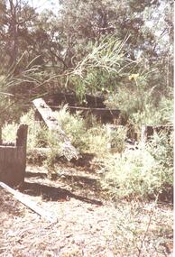
... An old bridge at Back Creek on the Heatherlie Quarry Rail... growth has grown over the bridge. An old bridge at Back Creek ...An old bridge at Back Creek on the Heatherlie Quarry Rail line.Photo shows the beginning of a bridge that has become dilapidated with time. Large beams lie around covered in weeds. Bushy growth has grown over the bridge.structures, bridges -
 Halls Gap & Grampians Historical Society
Photograph - Coloured
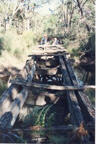
... An old bridge on the Heatherlie Quarry rail line at Back... on the Heatherlie Quarry rail line at Back Creek, this line was used ...An old bridge on the Heatherlie Quarry rail line at Back Creek, this line was used to transport sandstone from the quarry to Stawell.Photo shows an old bridge with 3 adults at the end, one male standing and 2 adults sitting. The bridge consists of large wooden beams,cross beams and supports .water can be seen at the bottom of the depression. Bush surrounds the bridge.structures, bridges -
 Orbost & District Historical Society
black and white photograph, c1920-1954
... on back - "Boggy Creek bridge - Nowa Nowa 1887 LaTrobe.... on back - "Boggy Creek bridge - Nowa Nowa 1887 LaTrobe Collection ...This is a copy of "THE BRIDGE AT BOGGY CREEK, NOWA NOWA, LAKE TYERS." which is a Rose Stereograph Co postcard. Boggy Creek Bridge was built in 1916 as part of the Bairnsdale to Orbost extension to the main Gippsland Railway, and is situated in the middle of the township of Nowa Nowa, crossing a steep-sided and well-timbered creek-valley. This section of the line closed in 1987. This bridge plays a major part in the identity and history of the town of Nowa Nowa, This item is associated with the East Gippsland Railway.A large black / white photograph of a large wooden bridge across a creek. There is a house and outbuildings in the background on the right. It is in a bush setting. on back - "Boggy Creek bridge - Nowa Nowa 1887 LaTrobe Collection"boggy-creek-bridge east-gippsland-railway